Trail Walking Les Gras - Le Mont Châteleu - Doubs - Photo

Le Mont Châteleu - Doubs

 tracegps
tracegps

User

© OpenStreetMap contributors
Length
Length
12.8 km
Max alt
Max alt
1289 m
Uphill gradient
Uphill gradient
539 m
Km-Effort
Km-Effort  
20 km
Min alt
Min alt
840 m
Downhill gradient
Downhill gradient
537 m
Boucle
Boucle
Yes
Creation date :
2014-12-10 00:00:00.0
Updated on :
2014-12-10 00:00:00.0

(1 Reviews)

Walking
Walking
4h00
Difficulty : Difficult

Scan this QR Code to open this trail in the SityTrail application

FREE GPS app for hiking

Logo SityTrail SityTrail

IGN / Geographical institutes

Download SityTrail from the App Store Download SityTrail from Google Play

Logo SityTrail SityTrail World

The world is yours!

Download SityTrail from the App Store Download SityTrail from Google Play Download SityTrail on Huawei AppGallery

About

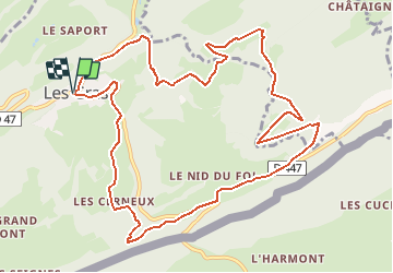
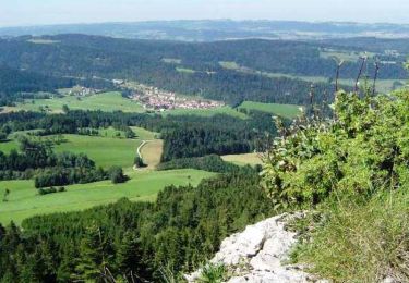
Trail Walking of 12.8 km to be discovered at Bourgogne-Franche-Comté, Doubs, Les Gras. This trail is proposed by tracegps.

Description

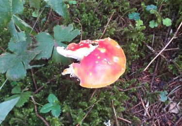
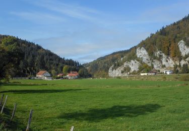
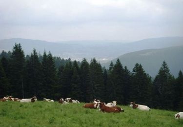
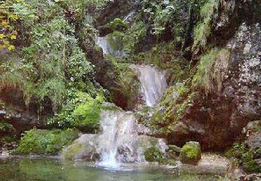
Le Doubs, réserve naturelle d’idées neuves ! Secteur géographique : Les Gras Intérêt du parcours : Sites naturels : Circuit qui chemine à travers les forêts et pâturages typique au val de Morteau et qui mène au Mont Chateleu (alt 1302m – table d’orientation) en passant par les chaudières, cavités creusées par l’eau dans le rocher A voir dans les environs : Grand’Combe-Châteleu : Ferme-Musées et artisanat local. Les Gras : Les Rochers du Cerf (alt 1210m). Importante colonie de chamois. Morteau : Château Pertusier, Eglise Notre Dame de l’Assomption, belvédère du Mont Vouiillot. Villers-le-Lac : Saut du Doubs, Musée de la montre, Musée de la radio, Chapelle des Bassots (XVIIIe Siècle).

Elevation profile

Photos

Positioning

Country:
France
Region :
Bourgogne-Franche-Comté
Department/Province :
Doubs
Municipality :
Les Gras
Location:
Unknown
Start:(UTM)
313268 ; 5207540 (32T) N.

Comments

Please log in to post a review or rate the element


Trails nearby

Trail Walking Les Gras - Les Gras
Walking
eltonnermou

Walking

Medium
Les Gras, Bourgogne-Franche-Comté, Doubs, France
13.3 km | 19 km-effort
4h 35min
Yes
Trail Walking Grand'Combe-Châteleu - Grand Combe Chateleu  - Photo
Walking
eltonnermou

Walking

Very difficult
Grand'Combe-Châteleu, Bourgogne-Franche-Comté, Doubs, France
17.2 km | 27 km-effort
6h 5min
Yes
Trail Walking Les Gras - les gras - Photo
Walking
eltonnermou

Walking

Medium
Les Gras, Bourgogne-Franche-Comté, Doubs, France
14 km | 21 km-effort
5h 3min
Yes
Trail Walking Les Combes - Remonot 8 octobre 2020 CAF - Photo
Walking
TRIMAILLE

Walking

Difficult
Les Combes, Bourgogne-Franche-Comté, Doubs, France
21 km | 32 km-effort
6h 44min
Yes
Trail Walking Les Gras - Le mont Châteleu - Photo
Walking
tracegps

Walking

Medium
Les Gras, Bourgogne-Franche-Comté, Doubs, France
18.5 km | 29 km-effort
5h 30min
Yes
Trail Walking Les Gras - Le Mont Chateleu - Photo
Walking
tracegps

Walking

Difficult
(1)
Les Gras, Bourgogne-Franche-Comté, Doubs, France
14.4 km | 22 km-effort
4h 30min
Yes
Trail Mountain bike Les Gras - Espace VTT FFC Val de Morteau - Circuit n° 13 - Les Gras - Photo
Mountain bike
tracegps

Mountain bike

Difficult
Les Gras, Bourgogne-Franche-Comté, Doubs, France
16.2 km | 24 km-effort
2h 30min
Yes
Trail Other activity La Brévine - y10_lac_tailleres - Photo
Other activity
GUIDE+

Other activity

Very easy
La Brévine, Neuchâtel, Unknown, Switzerland
5.1 km | 6.2 km-effort
1h 24min
Yes
Trail Walking La Brévine - wa19 - Photo
Walking
GUIDE+

Walking

Very easy
La Brévine, Neuchâtel, Unknown, Switzerland
16.9 km | 22 km-effort
7h 24min
No


Close
My subscriptions